When I was a kid, if people wanted local news, they read the paper in the morning and watched 30 minutes of local news on week-nights. Not particularly fast by today’s standards, but it was focused on local events.
Along the way came the rise of national 24-hour news channels, the internet with its increasingly fast data troves, the smartphones that potentially made everyone a reporter, and services like Craigslist that killed the remaining ad revenue for many local papers.
Even with all this data flowing, it’s harder for me to find out what is happening in my own town. Since our city chose to defund the police, violent crime and property crime have been on the rise. In fact, it has now become a right-of-passage for teenagers to steal cars because they know there will be no repercussions.
One of my neighbors recently saw a video on Facebook of her car being stolen and then used to steal another vehicle. Many of my neighbors were shocked to discover the level of crime around them that they were completely unaware of.
The people who knew were using local neighborhood apps such as Nextdoor or Facebook groups to report the events. I’ll be honest; I get raisin-face at the mention of these apps because, in my experience, they are largely just a bunch of people whining about nothing. However, as this case showed me, they can have a place in gathering timely, local information. Notice that I did not include accuracy in that statement. Like any other piece of intelligence, you have to consider the credibility of the source, and it has to be vetted against additional information.
If the internet is working, online services run live feeds of police and emergency service radio. Software-defined Radio can be receivers that are not much bigger than a thumb drive and allow your computer to receive a wide variety of signals. There are larger models, filters, and different antennas that can allow you to monitor all sorts of signals, including aircraft transponders and passing satellites with live weather feeds. And they are very inexpensive.
In the communications section, we discussed some ways to protect yourself from electronic eavesdroppers, but having a scanner or a radio with a scan function can also give you the ability to listen to others using radios nearby.
Spectrum analyzers, such as the TinySA, receive a broad portion of the spectrum and show the frequencies being used. They also show the signal’s visual signature so you can identify what sort of signal it is.
Even if you can’t decipher it, you can put that frequency in your radio and use a direction-finding antenna to locate the source of the transmission. If this is a skill you would like to cultivate, join a local radio club. The American Radio Relay League sponsors events called Fox Hunts, where a low-power radio is hidden, and participants locate it based on direction-finding techniques.
If you choose to shape your environment in any way, especially during a crisis, it’s best those actions do not occur in front of your house.
Suppose you can use some of these sources of information to determine the best direction you should take. In that case, you may be able to engage in dissuasion operations far enough away that no one can determine where you live or where you came from.
I have more than a decade of dog walks and bike rides to work, so I know all the routes, where the troublemakers live, the ethnicity of the neighborhoods, and even who has a convenient trash can to drop off a dog-poop bag.
If you are going to use technology such as night vision or drones to increase the effectiveness of your patrol make sure you train with them in advance. In the early 90s, I did a parachute exercise with the 82nd Airborne. We Marines still had one set of night vision goggles per team, but the 82nd had just been issued one per person.
Sitting in a hide-sight was very interesting, and seeing all the soldiers walking around using NVGs like they were in a video game. They still moved in formations but stood out in the open and did not take cover during engagements. We worked with them again a few months later, and they had adopted. Make sure you train your movement with your night vision devices if that is how you plan to use them.
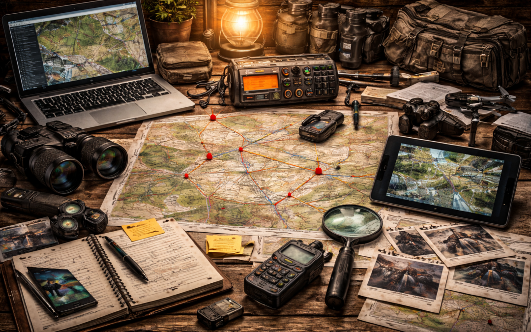
Google Earth has compiled a ton of map and satellite imagery that used to be spread over various sources. It is a valuable information source, but hard copies will be grainy and less detailed unless you have a good printer. I recommend getting maps and imagery from the United States Geological Survey. You can choose the maps’ center point, scale, and other details, and they are very detailed, high-quality resolution.
If you can access drones, they are a great way to update local imagery information.
If I were to take a walkabout either as an individual or on a team, I would not want a cell phone anywhere in the group. So, if you are planning to use a drone, I would start by selecting a model with a dedicated controller, not one that utilizes your cell phone.
Vary your launch points. Remember they are louder at 2 a.m. or when the power is out. Drones can be useful for you, but they can be tracked back to your recovery location. Based on drone usage in Ukraine, I’m sure we will continue to see new uses for drones develop, especially for those who are working with 3D printing.
Just by starting to work with the baseline data for these sources, you will start to be aware of other factors you would not have known otherwise. Recently, one of the two main access roads in my area had an emergency closure, and traffic was detoured.
Once upon a time, that would not have been of particular interest. However, since I had recently updated some information, I became curious about the backed-up traffic, the time of the detour, and the saturation of cars in the adjacent neighborhood. So, the next day I sat on a bench facing the street in question and recorded how many cars went by in 15 minutes. I could then estimate how many would pass in an hour. The bottleneck on the detour was a traffic light not designed for the volume of traffic it was managing. I calculated how many cars could pass through that choke point in an hour.
Will this piece of information ever prove useful? Maybe, maybe not. But it was interesting enough that I recorded similar information about the other main arterial where I live. Knowing this information may impact my timeline for evacuation triggers. Or it may not. In the end, it may just turn out to be a great collection and analysis exercise.
However, collecting this baseline information will reveal gaps and help you determine what other information you want. Then, you can walk the dog or drive to the store with a whole new purpose—filling those gaps, one at a time.
Now click on eBay and buy yourself that Special Reconnaissance T-shirt. Well… maybe not just yet.
Collecting and Processing Information
“Verification refers to the act of establishing or testing the truth or correctness of a fact, theory, statement, etc., by means of special investigation or comparison of data. Put another way, it is the act of seeking out corroborating evidence that would give us greater confidence that something is in fact true.”
When we look at information provided by Signals Intelligence or Imagery Intelligence, we look at objective information. We can see the objects in the photo, and the signal deviating from the baseline. We can use resources such as SigIdWiki to identify types of signals. For imagery, we can use sites such as TinEye to see how many websites a certain photo has appeared on or FotoForensics to see if a photo has been altered. While there may be some difference in how we analyze that information, the information itself has a high degree of reliability.
Human Intelligence and Open-Source Intelligence are more subjective and often require verification. People have agendas and reasons to share information. They are also not very good witnesses, so they may share a distorted view of events even when they are trying to be accurate.
List your facts. Where did they come from? Is there a way to confirm them with a second source? Is the information from a primary source, or is it repeated from some other source? What assumptions are being made?
Where did the information come from? Is the source in a position to know the information firsthand? Is the source new and unproven? Does the source have a history of reliable information? Does the source have a history of mixed results?
Is there a way to confirm with a secondary source? Recently I read an article that was carried by several newspapers. In this case, it was in several papers but there was no independent verification. All the articles referenced an original article by a well-known paper. But once I found the original article it seemed to be based on a single source of information. So, in this case, all those news articles relied on just one source of information.
What is the credibility of the source? Do they have an established history of accuracy? Can we place more weight on their information based on their history? What is the time value of the information, and what are the consequences if it is wrong?
Really consider the information. What assumptions are being made by the source? Are they assuming the information is accurate based on their own feelings about the subject? Are they presenting the information based on how they think you want to hear it?
Analysis of Information
We will never have all the information. Therefore, as new information is discovered, we must be ready and able to adapt our analysis accordingly. The most basic analysis of information can follow three types of logical reasoning; deductive, inductive, and abductive.
Deductive Reasoning is making an inference based on two or more pieces of information you already know to be true, deducing that some additional information must then be true. For example, my shoe is made of soft rubber; nails penetrate this type of soft rubber. Therefore nails will penetrate my shoe. Let’s apply this to a tactical problem where the information is less certain:
- This morning, a drone observed a supply convoy to a local occupation outpost that was 50% larger than normal.
- The last time this occurred, the local outpost increased the frequency of their patrols.
- It is a highly probable deduction that the outpost will soon increase the frequency of their patrols.
We used the deductive process correctly. The historical point is true, but it is not the only possibility, so our deduction may not be accurate.
Inductive reasoning is taking one or more things we know to be true and applying them to a larger problem. For example, political polling takes the responses from a few thousand people and purposes that it applies to a larger group of people. Let’s take our convoy example a step further:
- Reports have come in all morning indicating that many of the resupply convoys servicing nearby outposts were 50% larger than normal.
- There is no historical information for comparison nor any additional intelligence.
- We may inductively anticipate there will be a major coordinated effort in our area soon.
Again, this is just a best guess based on limited information.
Abductive Reasoning is the simplest and most likely conclusion based on available information. Most people are familiar with Occam’s Razor, popularly translated as the simplest explanation is often the best.
So, at this point, let’s consider the available information:
- This morning, a drone observed a supply convoy to a local occupation outpost that was 50% larger than normal.
- Radio traffic has reported similar observations all over the area.
Let’s ask the question, “What are other reasons we may see this?”
- There may be a coming increase in the size of the forces at the outposts.
- There may be a change in the frequency of the resupply convoys.
- There may be a change in mission at the outposts.
Now let’s consider all the possibilities we have identified:
- Historically, they increased patrols.
- There may be a coming increase in the size of the forces at the outposts.
- There may be a change in the frequency of the resupply convoys.
- There may be a change in mission at the outposts.
Considering that only one conclusion has any additional support, we apply abductive reasoning and select “expected increased patrols” as our current most probable analysis. This is always subject to change as new information is available.
Just as a parenthetical point of interest. I had a logic professor who had left Russia at the earliest opportunity after the fall of the Soviet Union. She explained that most Western research was based on deductive reasoning, but the dominant Soviet thinking was inductive. Her job in the Soviet Union was translating Western science papers and journals into Russian. But she had to rewrite the research so that instead of Western scientists knowing two or more pieces of information and deducing the outcome, she would write it as if they had observed the outcome first and induced why it had occurred.
Imagery Limitation and Field Sketching
Overhead imagery is limited when it comes to micro terrain, especially if there are rolling hills or depressions that are too minimal to show up on a topographic map.
In this example of a park. Let’s say you need to observe the bridge. You look at overhead imagery and determine you can see the bridge entrance from the parking lot.
However, when you show up and try to observe the bridge from your car, you discover you do not have a line-of-sight. In other words, the gently rolling terrain makes it impossible for you to see your target.
In situations that require ground-level line-of-sight, reconnoiter the sight ahead of time. Google Street View can help as long as the service has mapped the area.
The military uses two types of field sketches depending on the need. The first utilizes an overhead point of view and is useful for things such as a machine gun emplacement. It shows the top-down view, including elevations and depressions that prevent observation from that position. The lateral limits mean how far the gun shall aim to the left and right and the distances to easily identifiable objects in the gun’s field of fire. This allows the gunner to quickly choose the correct distance to new targets by their relation to those known points.
The point-of-view field sketch is another version more often used by surveillance and fire-support personnel. It records all the same information but from the ground line-of-sight view. One reason this point of view is favored by observers who control fires such as artillery is that the correct range to target is hard to estimate.
You can quickly use scopes and binoculars to make left-right corrections, but depth is much less accurate. There are several ways to measure the depth to easily identifiable objects or to a single-point target itself.
When you make this type of sketch, start with the horizon or in a forested area where the open terrain meets the base of the tree line. Draw it across about a quarter down on your page.
Then draw in all the prominent terrain features between you and that horizon. Note depressions you can’t observe, such as defilade; these are the back sides of hills.
Then, fill in buildings, trees, fences, and any other easily identifiable features. Try to find something close to the start of the unobservable area and something close to where your observation returns. This way, you’ll know how big the unobservable area is.
Then determine the distance from you to each major feature on your sketch. There are several ways to do this.
The first is estimating the range based on your best guess of how many football fields are between you and the object. Label several key features however you choose. On a separate sheet of paper, record your best guess of distance. This will be the least accurate.
From there, I would go to an analog range tool. This method has recently come back into fashion, so it is easy to find cards to hold out at a certain distance from your eye. Match a scale to an object such as a fence post or truck, and it will give you an estimated range. Scopes with range estimation tools or mil dot scopes also fall into this category. Record this estimation.
Next, I measure the range to target on my map and record those distances. This is starting to get a lot more accurate. Record this estimation.
Finally, I use a laser. This is usually the most accurate method, but it takes practice. Sometimes, you have to learn to trick the laser into returning a value on a correct target, such as shooting the base of the object or the ground just in front of the object.
Why do all this? Well if shit is going down your going to use the single most available method and just go with whatever is available. I go through this process to better calibrate my initial football field estimations.
Now, on your sketch, record the most accurate distances to each significant object.