Last summer, we took a trip to the Oregon Coast. We thought it would be fun to do it old school, using a road Atlas and no GPS. I was embarrassed at how out of practice I was with what should have been the simplest of navigation. I missed signs and turns because, over the last decade, I increasingly got comfortable letting a GPS audibly give me directions.
I have also noticed that if I look at a map of somewhere new and read the roads and turns, I will learn the way to that new place in one or two trips. If I follow GPS directions, it will take me many more trips to learn the route.
This is the most basic of navigation skills, and many young people have no idea where to start. Challenge yourself to get back to old-school car or city navigation. You can always check a GPS from time to time, but don’t make it your primary.
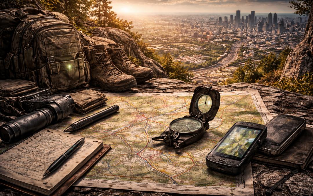
Now let’s move on to what initially came to mind when most people saw the word navigation, the map and compass.
This is too big a topic to cover here. I recommend you find a local organization that teaches land navigation in real-life courses. Frequently, a group like REI or The Mountaineers offers local instruction. There are some excellent books on the topic, but they should augment your real-life training, not supplant it.
If you have map and compass navigation skills or have newly acquired them, a great way to hone them is to try Orienteering. Orienteering clubs host competitions where teams run through an unmarked course using only a map. Thus the term orienteering because you are comparing the map to your surroundings and orienting it to figure out your next route.
The difference between orientation and map-and-compass land navigation is the use of the compass and headings. Typical map-and-compass use is to find where you are on the map, determine a waypoint between where you are and where you want to go, use the compass to determine the heading and distance, and then follow that heading on the compass to get you to the next point.
However, it is seldom as simple as what I just described. You will drift, encounter obstacles, and generally make some mistakes here and there.
For orienteering, you find yourself on the map. Look for easily identifiable terrain features, such as a road, crossroad, building, bridge, etc. Orient your map, and off you go. Once you get close, do it again.
When I was in the Marine Corps, we used a combination of land navigation and orienteering. Orienteering is much faster. But if you are using mortars and artillery to cover your butt, you better know where you are. Of course, GPSs came along and simplified things. But if your GPS fails or gets spoofed, you better know how to locate yourself and get to where you need to be.
Urban Design
Urban areas consist of complex man-made terrain, a population, and the infrastructure to support them. The five functional areas are the city core, residential areas, industrial areas, commercial or high-rise areas, and possibly a military zone.
Depending on where in the world it developed, the time it developed, and its size, a city may have developed organically or in a planned layout. Most cities are some combination of both.
When cities develop organically, housing pops up where needed, as does industry and shops. This usually results in winding streets that are hard to navigate. It also has higher rates of fire and disease. So, along came zoning and planned cities, which are easier to manage and upgrade with systems such as power, water, and sewage.
Both organic and planned developments are likely to have winding streets, dead ends, and cul-de-sacs. Planned cities may have grid or radial portions of the city.
From a historical military occupation of cities point-of-view, winding streets and cul-de-sacs are assets to defenders in that they can assemble and move while remaining undiscovered for longer. This has been largely mitigated through the use of drones. These same street designs are an asset for the occupiers because they naturally have many choke points to control movement, especially vehicle movement.
From a historical military point-of-view, grid streets are easier to control because fewer sentries are needed to observe between intersections. But in the modern era, if no sentries are posted, the grid allows the defenders multiple avenues of movement. Again, mitigated to some degree through the use of drones.
While crowds in civil unrest probably do not purposefully utilize these factors for both sides, the principles remain. If you understand the impact certain chokepoints may have on you, your ability to evacuate, and your access to supplies, it may impact how you choose to plan or mitigate that impact.
You should also remember that in most modern cities, there is another city. The subterranean network of tunnels and pipes often spans the city and usually traces the roadways above it.
You should be familiar with these local underground systems even if you don’t plan to utilize them. Manhole covers typically weigh about 250 pounds. Can you press that with one arm while holding onto a ladder with the other? Rain, even miles away, can cause flash floods in the tunnel system, which have nowhere to go but downstream. Gas pockets can form in low-lying areas, rendering you unconscious and leading to death.
However, that is not always the case. Historically, they have been used by groups to traverse cities and are included in modern military doctrine as a means of movement. The military even builds them into its training facilities.
The city’s commercial, residential, and industrial parts will have different structures, transportation systems, and roadways. Population density will vary by day and time of day.
Navigating in a city can become more challenging during periods of unrest. Protestors, criminals, and government forces may make certain routes or parts of the city inaccessible. Blockades, rubble, and fires may also limit access and force you to use routes you may not be familiar with.
Defenders frequently damage or remove street and road signs to slow the advance of government or occupying forces.
Military and government forces mitigate these impacts through the use of GPS and the preparation of special maps. For example, they may assign numbers to all structures in an area to minimize confusion if a unit is reporting on action or requesting fire on a specific building.
In today’s world, you have access to maps and satellite photography of cities through the use of services like Google Earth. You can even create overlays to mark routes or boundaries if you want. These can be printed or downloaded in advance. Many navigation apps allow you to download maps on the device, negating the need to connect to the internet.
For example, you can use a cheap Android tablet with no cellular connection hardware. Download the maps in advance and track your movement through the device’s GPS reception or through the GPS reception of a connected device such as a watch. Now you have a passive receive-only navigation option.
Transportation in, around, and out of a city experiencing civil unrest may be restricted by the scale and location of the disruption, as well as where you are trying to get to. Your car may experience the greatest amount of restrictions for routine travel or scouting. Walking may give you the greatest freedom of mobility.
The Marine Corps has recently added electric motorcycles to its Reconnaissance Course. Fast, quiet, highly mobile, expanding the terrain you can observe, and easy to hide, electric bicycles or motorcycles might be well worth considering.